Click on any image for a larger version
Current Through 12:20 am 04.17.2020
 |
Touchdown locations of the 19 Tornadoes on April 8-9, 2020 |
 |
| Track Map #1 Versailles, IN, Ripley Co. Link to NWS ILN Statement |
 |
| Track Map #2 north of Friendship, IN, Ripley Co. Link to NWS ILN Statement |
 |
| Track Map #3 starts south of Dillsboro, IN in southern Dearborn Co. ends in rural Ohio County, IN Link to NWS ILN Statement |
 |
| Track Map #4 starts in rural Ohio County, IN and ends just south of Rising Sun, IN Link to NWS ILN Statement |
 |
| Track Map #5 Just east of Warsaw, KY in Gallatin Co, KY Link to NWS ILN Statement |
 |
| Track Map #6 Northwest of Dry Ridge, KY in Grant Co. Link to NWS ILN Statement |
 |
| Track Map #7 Across southern Pendleton County, KY south of Falmouth Link to NWS ILN Statement |
 |
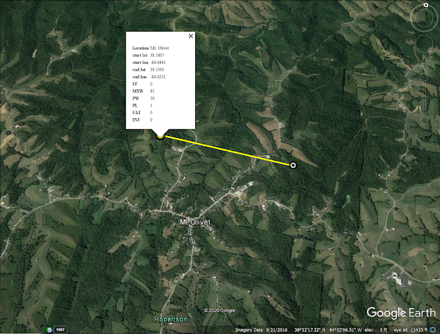
| Track Map #8 North of Mt. Olivet, Robertson County, KY Link to NWS ILN Statement |
 |
| Track Map #9 Near Mays Lick, soutern Mason County, KY Link to NWS ILN Statement |
 |
| Track Map #10 Near Edenton, OH, northern Clermont County, OH Link to NWS ILN Statement |
 |
| Track Map #11 From southeast of Blanchester in southern Clinton County Ohio into rural northern Brown County, Ohio. Link to NWS ILN Statement |
 |
| Track Map #12 Newtonsville, OH in northern Clermont County to Lake Lorelei, northern Brown County Ohio Link to NWS ILN Statement |
 |
| Track Map #13 From south of Lake Lorelei to south of Fayetteville, Ohio in Brown County. Link to NWS ILN Statement |
 |
| Track Map #14 From near Kenwood across Indian Hill in Hamilton County, Ohio. Link to NWS ILN Statement |
Track Map #15 From near Northgate Mall across
Springfield Township and Mt. Healthy past
Finneytown into Wyoming, Hamilton County, Ohio.
Finneytown into Wyoming, Hamilton County, Ohio.
 |
Track Map #16 Far southwestern Ohio County, IN.
|
 |
Track Map #17 Cross Plains, Ripley County, IN.
|
 |
Track Map #18 Between Farmers Retreat and Dillsboro,
Dearborn County, IN |
 |
Track Map #19 North of Bracht, KY Kenton County, KY
|

