Updated 06.22.2013 20:45z
Introduction
In Part I of this post I covered the basic meteorological setup of the El Reno, OK EF5 tornado of May 31, 2013. It was the widest tornado ever measured in the U.S. with a maximum width of 2.6 miles (4.2 km).The former record holder was the Wilber - Hallum, NE tornado of May 22, 2004 which was 2.5 miles (4.02 km) wide.
In Part II I take a look at radar data, more of it than you would normally see on a TV weather program. I hoped to post this a couple days after the first post but this is so much going on with this tornado that I had to go back and review a number of journal articles to clarify this complicated tornado.
Incredible Storm Chasing Video
If you think the only dangerous part of a tornado is the funnel, KFOR Meteorologist Emily Sutton probably has some advice for you. Take a look at what she and her crew got into while chasing the El Reno tornado.
Here is the video link:
http://www.youtube.com/watch?v=UjZDY142Y-Q
In an email about her close call Emily wrote "I'm blessed to be alive". After staring at the radar data for hours and hours, I think that is an understatement. Emily and Kevin Josefy got about as close as a chase team can get and live to tell the story. Her encounter was on the same road and a very short distance from where professional storm chasers Tim Samaras, his son Paul Samaras and Carl Young were killed and not too far from where the tornado ripped the hood from the armored tornado attack vehicle called The Dominator.
In Emily's opinion she got into an intense rear flank downdraft (RFD) and the air sinking behind the tornado was screeching towards and into the tornado circulation.
RFDs are known to at the very least help intensify mesocyclone tornadoes and there is mounting evidence that they may be an essential element of tornado formation by supplying air to the surface beneath the cloud base and updraft. RFD air wraps around and confines funnel rotation, concentrates the spin and helps bring rotation to the surface. As the updraft stretches the rotating air vertically the funnel narrows and the rotation rate increases. Think ice skater.
When discussing the storm with Reed Timmer meterologist, storm chaser, tornado attack vehicle designer and Discovery Channel star who also chases for KFOR TV, Reed told Emily it was probably an inflow jet that smashed the back windshield of her chase SUV as her team were in a backwards mad dash to avoid the El Reno tornado.
An inflow jet is just what it sounds like it is. Because of the extremely low pressure in the tornado air rushes in from all directions. When tornado-bound air is confined to a narrow channel, for example by the gust fronts of the RFD or the forward flank downdraft (FFD) of a newly forming upwind supercell (in this case to the west-southwest) air rushes into the vortex.

Inflow jets can be fed by RFD air and driven to impressive velocities. Inflow jets can also race parallel to the RFD gust front independent of the RFD itself. In fact inflow jets can be found almost anywhere around a tornado as air screaming into the incredible pressure falls of a tornado vortex interact with terrain, other inflow jets and neighboring storms.
Doppler radar images from the El Reno - Yukon tornado tell an incredible story. And it looks like both Emily Sutton and Reed Timmer are right about the presence of RFD air and inflow jets. Ultimately data indicates Emily was just on the edge of the tornado circulation when it was at it widest and strongest. Luckily far enough to sustain only a broken back windshield.
Radar data shows the El Reno - Yukon tornado was complicated and there is ample evidence of a strong RFD which wrapped around the tornado vortex as a strong inflow jet. In addition it is possible that a newly formed supercell may have helped channel and intensive the RFD inflow.
Supercell Fundamentals
The diagrams below show what you will find in most tornadic supercell environments. The specific geometric arrangement varies from storm to storm and not every feature that you see in these generalized schematics may be present in each storm. You have to think in 3D to get a full understanding of what is going on.
A supercell is a thunderstorm with, by definition, a tilted, rotating updraft. Because the updraft is tilted most of the rain falls outside the updraft. In a thunderstorm if the updraft is vertical rain falling through the updraft works against the rising air. A thunderstorm with a vertical updraft has a short lifetime while a supercell can last 12 hours and travel hundreds of miles.
The tilt is the result of vertical wind shear, that is, wind speeds increase with increasing elevation so the top of the updraft is farther downwind (farther in the direction of storm motion) than the updraft base.
Supercell rotation is largely a matter of the storm importing rotation from the environment, although there are mechanisms internal to the supercell that can create rotation also. In general meteorologists use the term vorticity to measure rotation and for qualitative discussions vorticity and rotation can be considered to be the same thing.
For more on rotation imported into thunderstorms use this link to a post about the March 2, 2012 tornadoes south of Cincinnati, OH:
http://insidetheforecast.fox19.com/
Heavy rain ahead of the updraft core creates the Forward Flank Downdraft or FFD. The cool rush of air you feel just before the heavy rain and the arrival of the thunderstorm is the Forward Flank Downdraft.
There are two mechanisms that account for the FFD Downdraft:
If you are not yet completely comfortable with stormglish ( aka chase speak), refer to these diagrams for reference during the following discussions.
Radar Loops
Reflectivity, Radial Velocity and Normalized Rotation
May 31, 2013 - KTLX Radar (Norman, OK NWS Office)
If these animated gifs are not looping, either refresh your browser or left click on the image to display the larger version in the blogger image viewer.


Introduction
In Part I of this post I covered the basic meteorological setup of the El Reno, OK EF5 tornado of May 31, 2013. It was the widest tornado ever measured in the U.S. with a maximum width of 2.6 miles (4.2 km).The former record holder was the Wilber - Hallum, NE tornado of May 22, 2004 which was 2.5 miles (4.02 km) wide.
In Part II I take a look at radar data, more of it than you would normally see on a TV weather program. I hoped to post this a couple days after the first post but this is so much going on with this tornado that I had to go back and review a number of journal articles to clarify this complicated tornado.
Incredible Storm Chasing Video
If you think the only dangerous part of a tornado is the funnel, KFOR Meteorologist Emily Sutton probably has some advice for you. Take a look at what she and her crew got into while chasing the El Reno tornado.
Here is the video link:
http://www.youtube.com/watch?v=UjZDY142Y-Q
In an email about her close call Emily wrote "I'm blessed to be alive". After staring at the radar data for hours and hours, I think that is an understatement. Emily and Kevin Josefy got about as close as a chase team can get and live to tell the story. Her encounter was on the same road and a very short distance from where professional storm chasers Tim Samaras, his son Paul Samaras and Carl Young were killed and not too far from where the tornado ripped the hood from the armored tornado attack vehicle called The Dominator.
 |
| Meteorologist Emily Sutton, KFOR TV, Oklahoma City. Courtesy KFOR.com |
In Emily's opinion she got into an intense rear flank downdraft (RFD) and the air sinking behind the tornado was screeching towards and into the tornado circulation.
RFDs are known to at the very least help intensify mesocyclone tornadoes and there is mounting evidence that they may be an essential element of tornado formation by supplying air to the surface beneath the cloud base and updraft. RFD air wraps around and confines funnel rotation, concentrates the spin and helps bring rotation to the surface. As the updraft stretches the rotating air vertically the funnel narrows and the rotation rate increases. Think ice skater.
 |
| Top: Meteorologist Reed Timmer and and an early version of The Dominator. Below: Current version of The Dominator . Courtesy: Discovery Channel |
An inflow jet is just what it sounds like it is. Because of the extremely low pressure in the tornado air rushes in from all directions. When tornado-bound air is confined to a narrow channel, for example by the gust fronts of the RFD or the forward flank downdraft (FFD) of a newly forming upwind supercell (in this case to the west-southwest) air rushes into the vortex.

Inflow jets can be fed by RFD air and driven to impressive velocities. Inflow jets can also race parallel to the RFD gust front independent of the RFD itself. In fact inflow jets can be found almost anywhere around a tornado as air screaming into the incredible pressure falls of a tornado vortex interact with terrain, other inflow jets and neighboring storms.
Doppler radar images from the El Reno - Yukon tornado tell an incredible story. And it looks like both Emily Sutton and Reed Timmer are right about the presence of RFD air and inflow jets. Ultimately data indicates Emily was just on the edge of the tornado circulation when it was at it widest and strongest. Luckily far enough to sustain only a broken back windshield.
Radar data shows the El Reno - Yukon tornado was complicated and there is ample evidence of a strong RFD which wrapped around the tornado vortex as a strong inflow jet. In addition it is possible that a newly formed supercell may have helped channel and intensive the RFD inflow.
Supercell Fundamentals
The diagrams below show what you will find in most tornadic supercell environments. The specific geometric arrangement varies from storm to storm and not every feature that you see in these generalized schematics may be present in each storm. You have to think in 3D to get a full understanding of what is going on.
A supercell is a thunderstorm with, by definition, a tilted, rotating updraft. Because the updraft is tilted most of the rain falls outside the updraft. In a thunderstorm if the updraft is vertical rain falling through the updraft works against the rising air. A thunderstorm with a vertical updraft has a short lifetime while a supercell can last 12 hours and travel hundreds of miles.
The tilt is the result of vertical wind shear, that is, wind speeds increase with increasing elevation so the top of the updraft is farther downwind (farther in the direction of storm motion) than the updraft base.
Supercell rotation is largely a matter of the storm importing rotation from the environment, although there are mechanisms internal to the supercell that can create rotation also. In general meteorologists use the term vorticity to measure rotation and for qualitative discussions vorticity and rotation can be considered to be the same thing.
For more on rotation imported into thunderstorms use this link to a post about the March 2, 2012 tornadoes south of Cincinnati, OH:
http://insidetheforecast.fox19.com/
Heavy rain ahead of the updraft core creates the Forward Flank Downdraft or FFD. The cool rush of air you feel just before the heavy rain and the arrival of the thunderstorm is the Forward Flank Downdraft.
There are two mechanisms that account for the FFD Downdraft:
- Each raindrop of the billions upon billions of drops pushes a bit of air towards the surface as it falls. The combined total can create and impressive wind gust when the descending air reaches the ground.
- Some of the raindrops evaporate on their journey to the surface cooling the descending air. Cooler air is more dense and adds to the velocity of the downdraft.
The abrupt change from warm muggy air to the gusty, cool air marks the leading edge of the FFD which we call the Forward Flank Gust Front. Just like the fronts on a weather map it is the boundary between contrasting air masses only smaller. The FFD Gust Front is also called an outflow boundary. As the cool air undercuts the less dense warm and humid air it helps to increase the lift on the air flowing into the thunderstorm. The FFD Gust Front can:
- Cause the supercell to become more intense due to the increased lift.
- Help generate rotation when the air is lifted along the gust front.
- Cause new cells or a squall line to form along the gust front.
The Rear Flank Downdraft or RFD is still a bit of a mystery with several candidates as possible mechanisms for formation of the RFD. The RFD is also the cause of several features that may contribute to tornado formation. The RFD is dry, sinking air behind the storm (relative to storm movement). It may be seen as a clear slot behind a tornado. It is likely the cause of the hook echo as the sinking dry air spirals into the mesocyclone. Radar sees the rain curtain as a spiral of high reflectivity and the air originating in the RFD a spiral lower or no reflectivity.
The leading edge of the RFD outflow is the RFD Gust Front and new cells that form along it are called the flanking line.
Possible causes of the RFD (all may operate together):
The leading edge of the RFD outflow is the RFD Gust Front and new cells that form along it are called the flanking line.
Possible causes of the RFD (all may operate together):
- Stagnation of mid-level air as it flows around the back side of the storm's updraft chimney. Pressure increases aloft forcing air to sink at the rear of the storm.
- Cooling of air flowing out of the storm aloft by evaporation or melting hail.
- Cooling of drier air moving into the storm from the rear also by evaporation or melting hail
- Dynamic effects that are beyond the scope of this post. Just think of it as what goes up must come down - an action/reaction pair.
Possible effects of the RFD:
- RFD outflow supplies air that wraps around the developing tornado vortex and confines the air to a narrower column helping to increase spin and velocity of the updraft. The updraft stretches the spinning column vertically and as the column narrows the spin rate increases.
- RFD air may transport rotation from aloft to the surface that aids in spinup of the tornado. Evidence for this is descending reflectivity cores (DRCs), areas of heavy rain that sink towards the base of the supercell rotating updraft.
- RFD air helps increase low level spin and may be crucial in bringing mesocyclone rotation to the surface or alternately in creating surface rotation that grows upward via the updraft joining the mesocyclone.
- RFD air sinks and is often warm and can arrive at the updraft as lower density air that is easily lifted.
- If there is insufficient air flowing into the updraft of a supercell a tornado cannot form.The RFD probably supplies air that helps maintain a tornado. In other words if the updraft can remove more air than can be pulled into the storm there will not be a large, long-track tornado. Meteorologists refer to the swirl ratio of the storm. In simple terms it is the ratio of inflow volume to updraft volume. As the swirl ration grows (> 1) the inflow air cannot be evacuated and the funnel becomes fatter eventually breaking dow to a multiple vortex tornado.
- New low-level mesocyclones may form on the RFD Gust Front and as the old mesocyclone occludes, that is it is absorbed by the supercell the new mesocyclone may generate a new tornado. These are called cyclic supercells and are the source of tornado families.
 |
A typical supercell and surrounding environment from above. The inflow jet shown is a "classic" situation. Because of the strength of tornado circulations inflow jets can develop from any direction. The inflow jet along the RFD gust front is most common. the RFD flow itself can accelerate into the tornado circulation also forming an inflow jet and interaction with terrain can confine inflowing air enough to cause a jet from any direction. For more investigate the "Venturi Effect".
|
 |
A typical supercell and surrounding environment from the side.
|
Radar Loops
Reflectivity, Radial Velocity and Normalized Rotation
May 31, 2013 - KTLX Radar (Norman, OK NWS Office)
If these animated gifs are not looping, either refresh your browser or left click on the image to display the larger version in the blogger image viewer.
 | ||

|

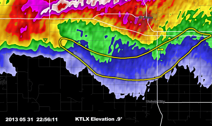 |
Same as above but at the second tilt elevation. In both this view and the view above a well defined RFD can be seen developing as a low reflectivity notch on the west side of the hook.
|
 |
| Two of 7 tornadoes in the Grand Island, NE area on June 3, 1980. the right funnel is a mesocyclone funnel and the debris on the left is from an anticyclonic (?) gustnado. See diagram below. |
 |
Ted Fujita's diagram of a cyclonic/anticyclonic tornado pair during the Grand Island, NE tornadoes of 3Jun1980 is similar to the radar view of the El Reno - Yukon tornado hook echo as it intensified and turned to the northeast with the end of the hook developing anticyclonic curvature. In the Grand Island event a small anticyclonic tornado developed. There was no such development in the El Reno - Yukon tornado. It is possible that the anticyclonic tornado developed on the RFD gust front as it occluded (curled into the center of the circulation), making the anticyclonic tornado a "gustnado". In the El Reno - Yukon case it looks like simultaneous strengthening of the RFD gust front and the FFD (forward flank downdraft) of the second cell created an intense inflow jet and the shear induced the anticyclonic curvature and rotation. See the diagram below.
|
 |
| Base velocity display. Red is air movement away from the radar (+ in polar coordinates), green is towards the radar (- in polar coordinates). A doppler radar can only measure movement directly along a radial so the display does not show true wind velocity or direction but the component of the wind along a radial. Because of this any wind that crosses a radial will have a doppler measured velocity slower than the true wind. |
 |
El - Reno - Yukon tornado. Background: base reflectivity, antenna angle 0.5° at 23:19:14z as the tornado was crossing U.S. Route 81, reaching maximum size and intensity and turning to the northeast. Red and Green outlines: location of GRLevel 2 Analyst derived positive (red) and negative (green) rotation. The red outline is for NROT approximately >= +1.0, the green outline is for NROT approximately <= -0.90. The area of anticyclonic (negative) rotation is shear induced as indicated by translucent white arrows. Inflow jet is shown. It is probably a combination of RFD inflow and the influence of the developing second supercell. The greatest inbound radial velocity is located at the small square (-140 kts/72.1 m/s).
|
 |
| Normalized Rotation ( Range +5 to -5, positive is cyclonic, negative anticyclonic, valuesbeyond +/-2.5 are extreme). This product is unique to GRLevel 2 Analyst and was developed by Gibson Ridge Software. It differs from rotation algorithms used in NWS radars. Because of the polar coordinate geometry native to radar systems data bins become larger as distance increases from the radar. A target of given size will occupy a decreasing proportion of the volume as distance increases. This means that velocity measurements slow as range increases which changes rotation calculations. In addition position within a volume becomes increasingly important with increasing distance from the radar due to increasing volume of data bins. The Gibson Ridge normalized rotation algorithm takes all this into account and from this example preforms well with both placement of the center of rotation and the change of intensity when compared to ground surveys. The strange behavior of the TVS symbol in the last couple frames is likely due to the multi-vortex nature and great width of the vortex/mesocyclone as it decayed. |
 |
| Same as above but with a graph of positive (cyclonic) and negative (anticyclonic) normalized rotation at an antenna elevation of 0.5°. Left click for a larger version. On the graph any value greater than 2.5 or less than -2.5 (the yellow lines) is considered to be extreme. |
 |
| Same as above but the map is for an antenna elevation angle of 0.9°. The left graph is for the 0.9° tilt and the right graph is the next tilt up 1.4°. Note the map scale is different from the map above to acomodate two graphs. Emily Sutton and Kevin Josefy were close, too close for comfort. Essentially they were within the outer fringe of the tornado's circulation when it was the widest and strongest. Contrast what Emily and Kevin did when faced with life a threatening situation to try and stay safe with what the Weather Channel crew did. Which crew acted the smart way? |
Radar Cross Section
Along a west (left) to east (right) line from
98.36° West Longitude to 97.65° West Longitude
Through the Center of Normalized Rotation @ Antenna Tile of 0.5°
 |
| Vertical reflectivity cross section, west to east (left >> right) through the center of normalized rotation. The BWER is squeezed as the mesocyclone occludes and moves northeast into the main body of the supercell. The RFD flow, wraps completely around the mesocyclone and is also squeezed as the next supercell grows and starts to merge with the supecell that caused the El Reno - Yukon tornado. In the last couple frames that have the RFD labeled there is also evidence that the RFD is undercutting the vortex. |
 |
| High angle view of the supercell's 40 dBz reflectivity from the southwest beginning 23:37:48z and ending 23:37:37z 31May 2013. Notice the following: 1. Areas of high reflectivity merging with the mesocyclone, 2. the well developed RFD (low or no reflectivity) as the hook reaches US Route 81 and the anticyclonic curvature develops and 3. the next cell trying to spin up. |

Medium angle view of 40 dBz reflectivity from the south-southeast beginning 23:56:14z and ending 23:37:37z. Careful observation reveals what are most likely descending reflectivity cores before the large curtain of rain wrapping around and into the circulation develops. Before the anticyclonic curvature develops the RFD is evident.

Medium angle view of 50 dBz reflectivity from the south-southeast beginning 22:37:49z and ending 23:37:37. What appear to be numerous descending reflectivity cores (DRCs) before and during the strengthening of the tornado descend and spiral into the mesocyclone circulation. The same thing happens with the development of the second supercell.
 |
| TDWR TOKC view of the evolution of the tornado, 1-minute time resolution. Antenna elevation angle = 0.5° |
Nice breakdown of this event. I am trying to find data to support or dismiss a theory I have as to how this tornado evolved and became so large. The initial tornado cyclone was located on the western edge of the parent meso with a vigorous surface based updraft on the eastern flank of the meso. The tornado cyclone rotated around the southern edge of the parent meso while the intense updraft persisted downstream (approximately 3 miles east of the tornado when it first developed) on the eastern edge of the meso. It appears this surface based updraft, while not exhibiting much rotation at the cloud base had very strong rising motion as it fed on moist inflow on the leading eadge of the RFD density current. I have video evidence of this and have found additional video evidence from other chasers. Now to the theory. The tornado's initial southeast movement appears to be directly tied to a very strong RFD surge pushing south on the back side of the meso. Exceptionally swift cloud motions from north to south on the backside of the tornado have been well documented. As the RFD and associated inflow jet pushed the tornado south and eventually wrapping around and then pushing the tornado cyclone east, the lead updraft continued to persist. It is my belief that these two features eventually merged south of El Reno and the result was a rapid increase in size as the entire mesocyclone essentially "set down on the ground". I do not have video evidence to support this as I was south of the tornado at this point with no view of the lead feature which would have been on the north side of the tornado. I have been looking over radar data trying to analyize the evolution of the tornado cyclone with my somewhat limited radar knowledge. The phased array radar loop http://www.srh.noaa.gov/oun/?n=events-20130531-radar shown here shows an interesting oscillation of the rotation which could be an indicator of this merger taking place. I would love to hear your thoughts on this. None-the-less this was an incredible, yet tragic storm. Seeing a 74-79 dewpoints and 50kt+ 0-6km shear that day was insane. It was obvious that the atmosphere had no choice but to produce violent weather that day.
ReplyDeleteThis is quoted from a research paper on the transition from multicell to supercell... "Greater moisture thus, greater environmental buoyancy (greater CAPE), and greater vertical wind shear together cause the size and intensity of cells and updrafts to begin to increase." >>>>> With 74°-79° F dewpoints and 50+ kts of 0-6 km shear, I'd say that would make one hell of a large, intense updraft. As for what you said, "the entire mesocyclone essentially 'set down on the ground'", I would guess when the tornado cyclone interacted with the intense updraft you spoke of, it caused the tornado cyclone to expand while maintaining/increasing it's rotational velocity, with the rotation below cloud base down to the surface likewise expanding while maintaining/increasing it's intensity.
ReplyDelete