What is VIL?
Vertically Integrated Liquid (VIL) is the total amount of rain that would fall if all the liquid water in a column inside a rain cloud (usually a thunderstorm) would be brought to the surface. Basically what you do is sum up (integrate) all the water in a column.VIL is not observed, it is calculated based on radar reflectivity. Because of that anything that affects reflectivity affects VIL.
VIL is not the same as precipitable water (PW). PW is a measure of the total water vapor in a column that could be condensed into rain.
The units for VIL are kg m-2. It may see, strange that when discussing a 3D cloud volume VIL is measured in kilograms per square meter but it makes a great deal of sense if you consider this:

- A cube of water, siting on the ground 1 meter on a side (a cubic meter) weighs 1000 kg (2,200 pounds or a metric ton).
- The depth of the water over the square meter of land covered is 1 meter or 39.37".
- So a VIL of 1000 kg m-2 is the same as 1 meter of rain or in English units 39.37".
- VIL values do not reach 1000 kg m-2 , this is just a reference value I use to explain the concept.
Now we can convert VIL values to inches of rain using this formula:
[VIL/1000] *39.37 = Inches of rain
Units Check:
[[kg m-2/kg m-3] *[in m-1]] = inches
Units Check:
[[kg m-2/kg m-3] *[in m-1]] = inches
or the simplified version
VIL * 0.03937 = Inches of Rain
VIL * 0.03937 = Inches of Rain
Example: VIL = 79.5 kg m-2
79.5 kg m-2 * 0.03937 = 3.13" of rain
We will re-visit this value shortly.
Liquid Water Does Not Float in the Atmosphere!
In fact neither do clouds. Sorry to burst your romantic bubble poetry fans, William Wordsworth was dead wrong when he penned the following:
"I wandered lonely as a cloud
That floats on high o'er vales and hills,
When all at once I saw a crowd,
A host, of golden daffodils;
Beside the lake, beneath the trees,
Fluttering and dancing in the breeze."
I Wandered Lonely As A Cloud
-William Wordsworth (1770 - 1850)
I Wandered Lonely As A Cloud
-William Wordsworth (1770 - 1850)
As a side note I do not think William Wordsworth would mind that I called him out, he also said:

OK! Enough English Romanticism, let's get back to radar meteorology.
Because raindrops, cloud drops, hailstones, and dust - all off which are found in a cloud - do not float in the atmosphere something must hold them up.
That something is the force of the updraft. Even in non-thunderstorm clouds - cloud materials are held aloft by updrafts which can be very weak in stratiform clouds.
The stronger the updraft the more liquid water than can remain aloft and the higher the VIL.
Strong thunderstorm updrafts also support large hail. But ... Does a large VIL value indicate large hail?
The stronger the updraft the more liquid water than can remain aloft and the higher the VIL.
Strong thunderstorm updrafts also support large hail. But ... Does a large VIL value indicate large hail?
VIL - What Is It Good For?
For years VIL was touted as having great potential for forecasting hail size. Large VIL values meant a strong updraft and that's where large hail is found.
In the 90s NWS even used something called VIL-of-the-Day (VOTD) to forecast hail size. It was not very successful because, VIL it turns out, is subject to many complicating factors.
The truth is, when used alone, VIL is a poor indicator of hail size for a number of reasons:
Complication #1
VIL is calculated using reflectivity and anything that has an effect on reflectivity will modify VIL.
For example, VIL was intended to measure liquid water only. To remove the contributions of ice to VIL reflectivity is capped at 56.5dBz. Any return greater than that is reduced back to 56.5dBz resulting in error when no ice is present but reflectivity from water content of an updraft is higher.
When hail is present VIL will be higher than if the column contained only liquid water.
Complication #2
VIL calculations show a raindrop-size bias. In the example below both cubes have the same reflectivity (Z). The left cube has 381.7 mm3 of water while the right cube has 14.1 mm3 of water. But because the two volumes yield the same reflectivity, VIL calculated for the left cube is the same as VIL for the right cube.

Complication #3
A thunderstorm too close to the radar can be partially obscured by the "cone of silence". Because part of the updraft is not sampled, VIL may be underestimated.
Complication #4
The VIL of a thunderstorm far from the radar can be exaggerated or VIL can be underestimated.
Because the altitude of the radar beam increases as it travels away from the antenna, the beam may overshoot the storm and underestimate VIL or pass right through a mid level hail core and overestimate VIL. If the storm is far enough away lower storm elevations are not sampled at all.
Complication #5
The upper reaches of the updraft core in tilted thunderstorms may extend out of the sampling volume into a neighboring grid box resulting in an underestimate of VIL.
Complication #6
A fast moving storm may move so much during the time it takes for an entire volume scan to be completed by a NEXRAD Doppler Radar the upper reaches of the updraft may move out of the sampled volume resulting in an underestimate of VIL.
Complication #7
The VIL equation assumes all reflectivity is from liquid water in the thunderstorm.
Even small hail is bigger than large rain drops. Hail is also solid and when water coated it backscatters much more energy than raindrops which increases reflectivity and therefore VIL.
When hail is present the calculated value of VIL is too high because of the high reflectivity of hail, not because of high liquid water content.
Complication #8
VIL is higher for wet hail than dry hail and both backscatter much more energy than even the largest raindrops.
If radar to storm distance is an issue - See Complication #4 above - the radar beam may pass through the top of the hail shaft where hail is usually drier giving a lower VIL estimate than if the beam passes through lower portions of the hail shaft or through the melting layer where water coated hail produces greater reflectivity.
Complication #9
VIL has air mass and seasonal dependencies primarily based on temperature structure and moisture availability.
The wet bulb temperature (Tw) is the temperature TO WHICH air can be cooled by evaporating water into a column of air.
The value of Tw is always greater than the dew point temperature (Td) temperature and less than the ambient air temperature EXCEPT at equilibrium (RH = 100%) when
Td = Tw = T.
The web bulb zero level is the lowest altitude where the air can be cooled to 0°C by evaporation.
As hail falls and melts and liquid water drops evaporate in air warmer than freezing the air column can be cooled enough to significantly lower the freezing level.
At elevations lower than the wet bulb zero level evaporation cannot cool the air to freezing so hail always melts as it falls.
When the wet bulb zero height is low (7000' for example) the radar beam samples hail or other frozen targets through a large vertical distance and VIL is likely to be overestimated and so is hail size.
When the wet bulb zero height, and by implication the freezing level, is high (14,000' for example) melting can take place rapidly and the radar sees a zone of enhanced reflectivity centered on the freezing level. Liquid drops through the large vertical distance beneath the wet bulb zero level return less energy than the hail above, meaning a lower estimate of VIL.
However if the storm is tall enough and the updraft strong enough the volume of hail above the freezing level can severely skew VIL calculations to higher values. See the case study below for more.
If the web bulb zero level is high enough even large hail may not make it to the ground.
How VIL and the wet bulb zero level interact is complicated by how warm the air is within a thunderstorm and how quickly it changes vertically (i.e. the environmental lapse rate).
Every storm is an individual with its own quirks.
SO ....
VIL is only good as a crude, first estimate of hail or hail size. When used with dualpol products and other observations like hail spikes (three-body scatter spikes) and melting layer altitude VIL is more effective.
HOWEVER ....
VIL is a good indicator of updraft strength, but beware of extreme values caused by hail.
AND
A rapid decrease of VIL may indicate a collapsing thunderstorm and the onset of a wet microburst.
FINALLY
VIL calculations are most accurate:
It just so happens that during the evening of Friday 21 JUL 2017, centered on 8:10PM EDT (00:10z 22 JUL 2017) just such a storm formed south of Cincinnati near Walton, KY.
Digital Atmosphere/Front Paint Surface Divergence Maps
Animated gif with pauses
RadarScope Loops - Data time - lower right corner.


With the very high VIL NWSILN was concerned about the development of a wet microburst and issued the following severe thunderstorm warning:
RAOB Plot
From the KILN sounding 00Z 22 JUL 2017
Freezing Level 16,192' msl
Wet Bulb Zero Level 14,427' - 15,320' msl
Low Wind Shear Environment
Note: The Wet Bulb Zero level is at most 1765' lower than the freezing level. If maximum evaporative/hail melt cooling took place the lowered freezing level was still very high. In the warm air below the lowered freezing level hail melt would be rapid and it is not likely that much, if any, hail would make it to the surface.

Maximum Reflectivity Profile from GR2Analyst
Maximum Reflectivity in the main updraft at 00:10z

44165' agl (8.0°) 52.5 dbz
35836' agl (6.4°) 56.0 dbz
28645' agl (5.1°) 57.0 dbz
23167' agl (4.0°) 61.0 dbz
18653' agl (3.2°) 61.5 dbz
14761' agl (2.4°) 65.5 dbz
8822' agl (1.3°) 60.0 dbz
6335' agl (0.9°) 61.5 dbz
4217' agl (0.5°) 56.0 dbz
Note that the maximum reflectivity (65.5 dbz) is just below the the freezing level on the KILN sounding. The high reflectivity is likely due to melting hail because water coated ice backscatters more radiation than ice or liquid water alone.
GR2Analyst Slice


Time Line of the Thunderstorm's Evolution
23:54 Updraft core reaches the freezing level.
00:05 Updraft core extends up to 48,000', Max VIL reached
00:10 Max VIL maintained, updraft core begins to weaken
00:16 Top of the updraft core down to 33k ft. VIL down to 51.4.
00:21 00:32 Top of updraft core - >+50 dBz - pulsing between 20 - 30k ft.
00:37 Top of 50 dBz core down to 17,000' agl.
00:48 All >=50 dBz of core gone.
GR2Analyst 3D Volumetric Animation
Animated gif with pauses
In the 90s NWS even used something called VIL-of-the-Day (VOTD) to forecast hail size. It was not very successful because, VIL it turns out, is subject to many complicating factors.
The truth is, when used alone, VIL is a poor indicator of hail size for a number of reasons:
Complication #1
VIL is calculated using reflectivity and anything that has an effect on reflectivity will modify VIL.
For example, VIL was intended to measure liquid water only. To remove the contributions of ice to VIL reflectivity is capped at 56.5dBz. Any return greater than that is reduced back to 56.5dBz resulting in error when no ice is present but reflectivity from water content of an updraft is higher.
When hail is present VIL will be higher than if the column contained only liquid water.
Complication #2
VIL calculations show a raindrop-size bias. In the example below both cubes have the same reflectivity (Z). The left cube has 381.7 mm3 of water while the right cube has 14.1 mm3 of water. But because the two volumes yield the same reflectivity, VIL calculated for the left cube is the same as VIL for the right cube.

Complication #3
A thunderstorm too close to the radar can be partially obscured by the "cone of silence". Because part of the updraft is not sampled, VIL may be underestimated.
Complication #4
The VIL of a thunderstorm far from the radar can be exaggerated or VIL can be underestimated.
Because the altitude of the radar beam increases as it travels away from the antenna, the beam may overshoot the storm and underestimate VIL or pass right through a mid level hail core and overestimate VIL. If the storm is far enough away lower storm elevations are not sampled at all.
Complication #5
The upper reaches of the updraft core in tilted thunderstorms may extend out of the sampling volume into a neighboring grid box resulting in an underestimate of VIL.
Complication #6
A fast moving storm may move so much during the time it takes for an entire volume scan to be completed by a NEXRAD Doppler Radar the upper reaches of the updraft may move out of the sampled volume resulting in an underestimate of VIL.
Complication #7
The VIL equation assumes all reflectivity is from liquid water in the thunderstorm.
Even small hail is bigger than large rain drops. Hail is also solid and when water coated it backscatters much more energy than raindrops which increases reflectivity and therefore VIL.
When hail is present the calculated value of VIL is too high because of the high reflectivity of hail, not because of high liquid water content.
Complication #8
VIL is higher for wet hail than dry hail and both backscatter much more energy than even the largest raindrops.
If radar to storm distance is an issue - See Complication #4 above - the radar beam may pass through the top of the hail shaft where hail is usually drier giving a lower VIL estimate than if the beam passes through lower portions of the hail shaft or through the melting layer where water coated hail produces greater reflectivity.
Complication #9
VIL has air mass and seasonal dependencies primarily based on temperature structure and moisture availability.
The wet bulb temperature (Tw) is the temperature TO WHICH air can be cooled by evaporating water into a column of air.
The value of Tw is always greater than the dew point temperature (Td) temperature and less than the ambient air temperature EXCEPT at equilibrium (RH = 100%) when
Td = Tw = T.
The web bulb zero level is the lowest altitude where the air can be cooled to 0°C by evaporation.
As hail falls and melts and liquid water drops evaporate in air warmer than freezing the air column can be cooled enough to significantly lower the freezing level.
At elevations lower than the wet bulb zero level evaporation cannot cool the air to freezing so hail always melts as it falls.
When the wet bulb zero height is low (7000' for example) the radar beam samples hail or other frozen targets through a large vertical distance and VIL is likely to be overestimated and so is hail size.
When the wet bulb zero height, and by implication the freezing level, is high (14,000' for example) melting can take place rapidly and the radar sees a zone of enhanced reflectivity centered on the freezing level. Liquid drops through the large vertical distance beneath the wet bulb zero level return less energy than the hail above, meaning a lower estimate of VIL.
However if the storm is tall enough and the updraft strong enough the volume of hail above the freezing level can severely skew VIL calculations to higher values. See the case study below for more.
If the web bulb zero level is high enough even large hail may not make it to the ground.
How VIL and the wet bulb zero level interact is complicated by how warm the air is within a thunderstorm and how quickly it changes vertically (i.e. the environmental lapse rate).
Every storm is an individual with its own quirks.
SO ....
VIL is only good as a crude, first estimate of hail or hail size. When used with dualpol products and other observations like hail spikes (three-body scatter spikes) and melting layer altitude VIL is more effective.
HOWEVER ....
VIL is a good indicator of updraft strength, but beware of extreme values caused by hail.
AND
A rapid decrease of VIL may indicate a collapsing thunderstorm and the onset of a wet microburst.
FINALLY
VIL calculations are most accurate:
- When a storm is a moderate distance from the radar
- The storm is moving slowly
- The updraft is vertical (not tilted) and
- The freezing level is high.
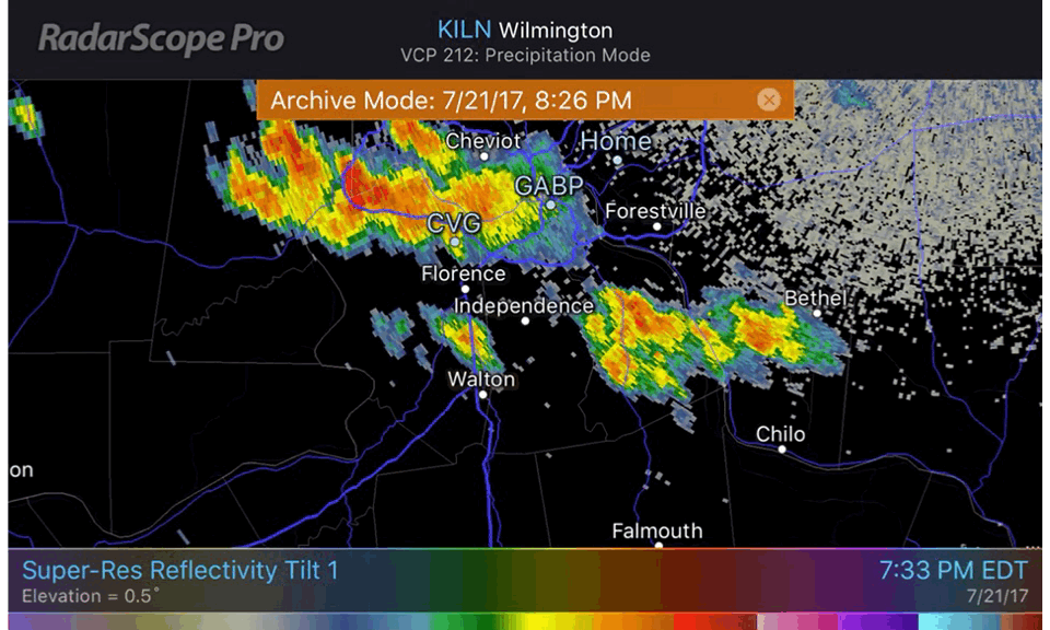
It just so happens that during the evening of Friday 21 JUL 2017, centered on 8:10PM EDT (00:10z 22 JUL 2017) just such a storm formed south of Cincinnati near Walton, KY.
Case Study:
High VIL Thunderstorm 21-22 July 2017
The cell we are talking about formed just to the northwest of Walton, KY along a non-frontal surface convergence line. The thunderstorm was moving towards the southeast at 5 mph, according to NWSILN's severe thunderstorm warning.
Digital Atmosphere/Front Paint Surface Divergence Maps
 |
| Quasi-stationary frontal positions are based on surface convergence only. Diffuse summertime fronts located in this manner may suffer from lack of continuity in position, i.e. show a great deal of motion in a short period of time. Plotted with Digital Atmosphere. Fronts drawn with Front Painter avaliable from weathergraphics.com |
The updraft core underwent explosive development growing 21,000 feet in 10 minutes. During the same period VIL increased rapidly from 55.5 to 79.5 kg m-2.
At 8:10 PM EDT 21 JUL 2017 VIL was measured at 79.5 kg m-2 equal to 3.13" of rain by KILN NEXRAD Doppler Radar.
At 8:10 PM EDT 21 JUL 2017 VIL was measured at 79.5 kg m-2 equal to 3.13" of rain by KILN NEXRAD Doppler Radar.


 |
| Courtesy: VTEC Browser, Iowa State University |
 |
| Courtesy: VTEC Browser, Iowa State University |
RAOB Plot
From the KILN sounding 00Z 22 JUL 2017
Freezing Level 16,192' msl
Wet Bulb Zero Level 14,427' - 15,320' msl
Low Wind Shear Environment
Note: The Wet Bulb Zero level is at most 1765' lower than the freezing level. If maximum evaporative/hail melt cooling took place the lowered freezing level was still very high. In the warm air below the lowered freezing level hail melt would be rapid and it is not likely that much, if any, hail would make it to the surface.

Maximum Reflectivity Profile from GR2Analyst
Maximum Reflectivity in the main updraft at 00:10z

54462' agl (10.1°) 37.5 dbz
44165' agl (8.0°) 52.5 dbz
35836' agl (6.4°) 56.0 dbz
28645' agl (5.1°) 57.0 dbz
23167' agl (4.0°) 61.0 dbz
18653' agl (3.2°) 61.5 dbz
14761' agl (2.4°) 65.5 dbz
8822' agl (1.3°) 60.0 dbz
6335' agl (0.9°) 61.5 dbz
4217' agl (0.5°) 56.0 dbz
Note that the maximum reflectivity (65.5 dbz) is just below the the freezing level on the KILN sounding. The high reflectivity is likely due to melting hail because water coated ice backscatters more radiation than ice or liquid water alone.
GR2Analyst Slice

RadarScope Individual Frames 8:05 PM - 8:10 PM EDT (00:05z - 00:10z)

Tilt 1 0.5° Beam Center Altitude at Walton 4054' Temperature 21.9°C

Tilt 2 0.8° Beam Center Altitude at Walton 6144' Temperature 17.8°C

Tilt 3 1.2° Beam Center Altitude at Walton 8480' Temperature 13.9°

Tilt 4 1.7° Beam Center Altitude at Walton 10792' Temperature 7.6°C


 |
| VIL, Reflectivity and hail-size contour (yellow). |
Evolution of the Thunderstorm

Time Line of the Thunderstorm's Evolution
23:54 Updraft core reaches the freezing level.
00:05 Updraft core extends up to 48,000', Max VIL reached
00:10 Max VIL maintained, updraft core begins to weaken
00:16 Top of the updraft core down to 33k ft. VIL down to 51.4.
00:21 00:32 Top of updraft core - >+50 dBz - pulsing between 20 - 30k ft.
00:37 Top of 50 dBz core down to 17,000' agl.
00:48 All >=50 dBz of core gone.
GR2Analyst 3D Volumetric Animation
Animated gif with pauses
 |
| 3D time lapse of the thunderstorm using GR2Analyst. Red is reflectivity >=50.5 dBz. |
Summary
SURFACE CONVERGENCE LINE - The thunderstorm developed in a high surface dew point environment along a non-frontal surface convergence line.
The convergence was likely due to a quasi-stationary front to the north, southwesterly winds on the back side of a surface high flowing towards the front and the interaction of terrain with the winds.
Despite the moist surface environment, total CAPE from the surface through 750 mb (hPa) was negative based on the nearest sounding at KILN.
Above the LFC through 100 mb (hPa) 16396 m/53792 ft. agl the total CAPE was 1545.4 J/kg explaining the explosive development.

LOW WIND SHEAR ENVIRONMENT - The vertical wind shear was small leading to a vertical (i.e. not tilted) updraft core.
EXPLOSIVE DEVELOPMENT - The updraft core underwent explosive development after 7:49 PM EDT resulting in a VIL of 79.5 kg m -2 that persisted for 5 - 10 minutes. Small to moderate hail developed enhancing reflectivity and therefore VIL.
Just as the 50 dBz reflectivity core began to decay (about 8:10 PM) a mix of hail and rain was observed on radar at KILN as low as 8565' agl. The sounding temperature at KILN at that level was approximately 13°C (55.4°F) leading to rapid melting.
It is not surprising given the warm atmosphere, rural location and time of day no hail was reported to NWSILN.
Animated gif

RAPID DECAY - The updraft core underwent rapid decay after 8:10 PM EDT and VIL decreased from 79.5 kg m-2 to 51.4 kg m-2 in 6 minutes.
A rapid decrease of VIL can mean a collapsing thunderstorm and that a wet microburst may be developing.
It can also indicate rapid melting of small hail and the decreasing influence of the enhanced reflectivity of water coated hail. In this case it looks like both were occurring.
The gradual decline of the storm's echo top on the KILN radar indicates the storm was weakening and not undergoing complete collapse even though the updraft core was rapidly weakening.
Check out my blog post on the Hilliard, OH microburst for an example of total thunderstorm collapse. Compare the 3D timelapses. You can find it here:
Hilliard, OH Microburst, July 10, 2013
By 8:13 PM EDT NWSILN became concerned about a wet microburst and issued a severe thunderstorm warning for winds gusts to 60 mph.
"POURING WATER DOWN THE CHIMNEY" - Because the updraft core was not tilted heavy rain and hail were falling through the updraft core. This is likely the mechanism for the short life of the strong core and its rapid demise.
The mechanical force of falling rain drops and hailstones combined with the thermodynamic effects of melting hail and evaporating rain worked against long-term maintenance of the updraft core.
A more detailed study may show terrain influences and competition for resources (moisture) with neighboring cells as additional causes of the quick decline.
THE LARGE VIL - was likely caused by a large volume of small to moderate hail and enhanced backscattering as the hail melted in the warm environment. As this hail melted a great deal of thermal energy was removed from the updraft core - another factor shortening the life of the updraft.
The hail was likely only small to moderate in size because the short life of the strong updraft did not provide enough time for large hail to grow. Small hail size was also a factor in the rapid the rate of melting.
SEVERE THUNDERSTORM WARNING/WET MICROBURST
In my opinion this warning was a "good" warning - justified by the information available at the time even though it is an un-verified warning.
Post-event analysis is different than real-time observation giving more time to dig deep into the available data unlike operational meteorologists at NWSILN who must make decisions quickly.
Post-event analysis indicates a wet microburst was unlikely because the large VIL observed was likely due to radar reflectivity enhanced by a large volume of small hail and a thunderstorm in decline not rapid collapse.
However, the KILN 00z sounding does indicate the potential for sufficient evaporative cooling to enhance downdraft outflow by observing the spread between Tw and T through a deep layer of the atmosphere (see the sounding plot).
FORECASTING MICROBURSTS
Take a look - this is cool!
Meteorolgical Software used in this post:
RadarScope Pro Tier 2
GR2Analyst
RAOB
Digital Atmosphere 2015/Front Paint
Other Software used:
Adobe Photoshop CC
Camtasia Studio
Microsoft Excel
GIF Maker (iphone)
Services Used:
VTEC Browser, Iowa State University
Level II Archive, Allison House
College of DuPage, METAR Archive


