The Tornadoes of 6 July 2022 near Cincinnati, OH, USA
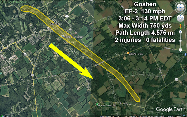
Around 3PM EDT 6 July 2022 three tornadoes touched down east of Cincinnati, two in Clermont County and one just east in Brown County. The maps below show the locations.
What Meteorologists Look for When Tracking Tornadoes on Radar
The video below, with an audio narration, shows the movement of the severe thunderstorms and outflow boundaries resulting in the three tornadoes. Tools I used: RadarScope, a professional level radar analysis tool, GR2 Analyst for the Normalized Rotation (NROT) data, Google Earth Pro, Photoshop and Camtasia Studio.In the video I show the interaction of an Outflow Boundary (OFB) and the severe thunderstorm as it approaches. You will see how there is a sudden increase of strength as the storm interacts with the outflow boundary.
Conclusions:
- The storm interacted with the outflow boundary and strengthened it just east of Goshen.
- The OFB did not "cause" the tornado, because the storm was rotating before it interacted with the OFB.
- The storm did not ride up and over the OFB the the rain cooled pool of air behind it as many storms do (videos below).
- Most likely the OFB acted to increase surface convergence ahead of the updraft core, strengthening the updraft enough to increase the rotation through vertical stretching see video below).
Stretching an Updraft and Increasing Rotation
A Typical Thunderstorm - No Audio
The next video, from my YouTube library, shows a schematic of a typical thunderstorm.
To be sure, "typical" does not mean all thunderstorms look exactly alike. You can pause the video and look at the diagram in more detail if you want to get a better feel for what's going on in and around a thunderstorm.
You can pause the video for a closer look. Be sure to look at the "Forward Flank Downdraft" or "Gust Front" another name for an "Outflow Boundary" (OFB).
The video below (this one has audio) shows how the pool of rain cooled air can increase lift, or upward motion, in a thunderstorm. In the Goshen tornado this may have played a part as the inflowing air wrapped around the rotation core and flowed into and upward through the storm.
It is more likely in this case that an "low level inflow jet" flowed parallel to the OFB and was "squeezed" (another way of saying surface convergence was increased) as it flowed into the storm and intensified the updraft.
I do not have enough radar evidence to be conclusive about this however.
Other Video Examples of Outflow Boundaries and Their Effects for You
All videos are silent.


