It may seem odd that the title this post contains two words from languages other than English. The German word blitzkrieg meaning "lightning war" and the Spanish derecho meaning "straight ahead" (pronounced day-RAY-cho). So first some history.
HISTORICAL BACKGROUND
As Dr. Hinrichs discovered in his research, a derecho is a strong line of thunderstorms. He used the Spanish word for "straight ahead" to describe the main cause of damage - straight line winds. As the story goes he wanted to be consistent with the term tornado which is also rooted in the Spanish language.
Tornado is from the Spanish verb "tornar" meaning to turn. Because both words, derecho and tornado, are derived from Spanish the plural forms of both derecho and tornado do not use the letter "e" before the "s". So the plural is derechos NOT derechoes and tornados NOT tornadoes. However "tornadoes" is more commonly used.
The name derecho was soon forgotten but finally resurrected in 1987 by National Severe Storms Forecast Center meteorologists Robert Johns and William Hirt in their paper, "Derechos: Convectively Induced Windstorms" (Weather and Forecasting, Vol.2 page 32).
That other foreign word in the title, the German term "Blitzkrieg", means "lightning war". During WWII it was a way of doing battle by striking fast and forcefully and quickly breaking through the defenses of the enemy. It is also very descriptive of how a derecho causes damage.
WHAT IS A DERECHO
A derecho is a long, line of thunderstorms (to the meteorologist a linear mesoscale convective system or linear MCS) that can live 12 hours or more, travel hundreds of miles and all the while generate straight-line winds in excess of 100 mph. While straight-line winds are its main feature tornadoes can be spawned and flooding rains and large hail can occur.
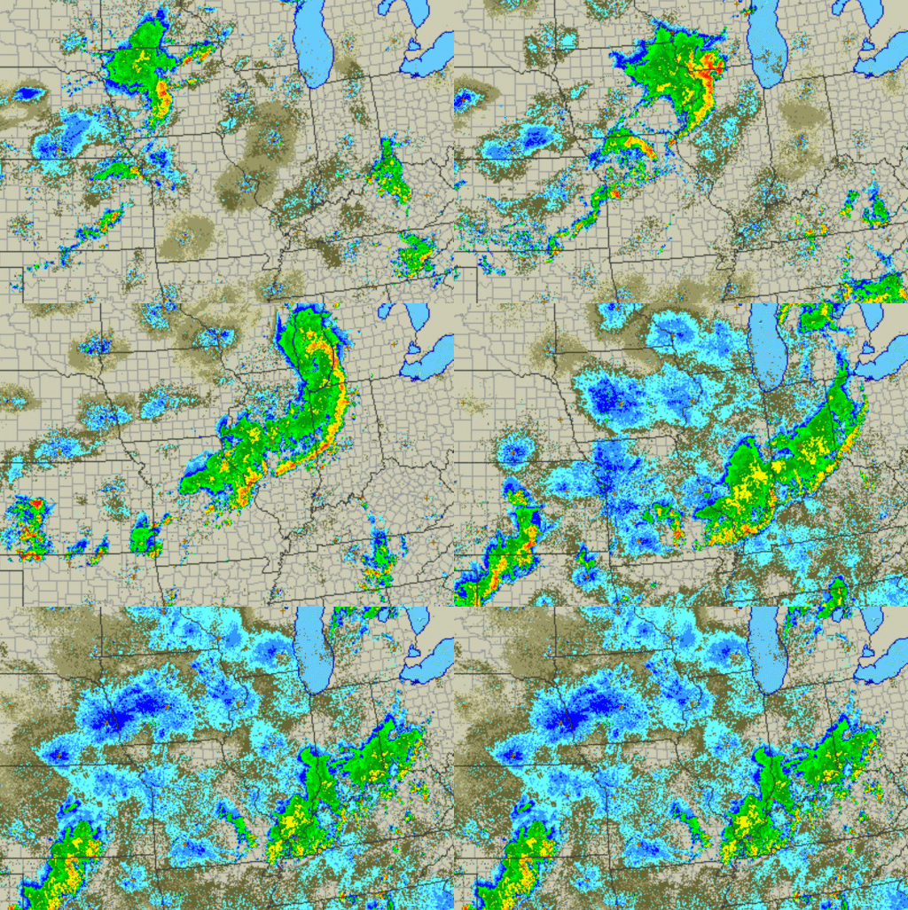
The image below is a radar history of the costly derecho of June 29-30, 2012 that visited the FOX19 NOW viewing area. It was the deadliest and most destructive derecho in American history. As many as 28 people lost their lives and 4 million lost power (1 million in Ohio). The highest wind gust was 91 mph in Fort Wayne, IN and hail as large as 2.75" in diameter fell in Bismarck, IL. It traveled 600 miles and lasted 18 hours.
MORE THAN ONE TYPE OF DERECHO
Hybrid Derecho - It has characteristic of both progressive and serial derechos.
Low Dew Point Derecho - Mainly a late fall to early spring phenomenon when the humidity of summer has withdrawn into the deep south. This is essentially a series of dry thunderstorm downbursts and has not received much study.
PROGRESSIVE DERECHO OF AUGUST 10, 2020
 |
| Derecho of August 10, 2020 Animation generated at http://weather.rap.ucar.edu/radar/ then screen captured with Camtasia and rendered as a gif |


