CLICK on any image for a larger view  |
| The Crittenden-Piner-Morning View EF4 tornado just after touchdown before it struck Piner, KY. Taken from south of Crittenden. .Photographer unknown. |
Three times in my 36 year career I have looked at the camera and told my viewers to stop watching and take cover immediately.
The first was June 2, 1990 when Harrison, OH and many other communities were struck by a F3 tornado (the EF system began Feb. 1, 2007).
The second time was during the early morning hours of April 9, 1999 when a F4 tornado struck first near Rexville, IN and travelled through Sycamore Twp. and Blue Ash.
March 2, 2012 was the third. That's an average of once time every 12 years.
No matter how long a TV meteorlogist is on the air, no matter what we do someone will not get the life-saving information they need. On March 2, 2012, 9 individuals died.
 |
| We tracked the supercells from 10:20AM EST (15:20z) until nearly 7PM EST (00z March 3). That 's 8.5 hours as they travelled more that 500 miles. |
Satellite Views
 |
| POES (Polar-orbiting Operational Environmental Satellite) NOAA-15 HRPT image strip taken on 02Mar2012, from 2133 to 2141z (4:33 to 4:41 PM EST). Tornadic thunderstorms moving through the Cincinnati tristate area. |
 |
| Enlargement of the NOAA-15 image strip above. Cincinnati at the yellow circle. |
 |
| The "V" shape indicates the storms were energized by a jet-streak which is a strong disturbance in the jet stream |
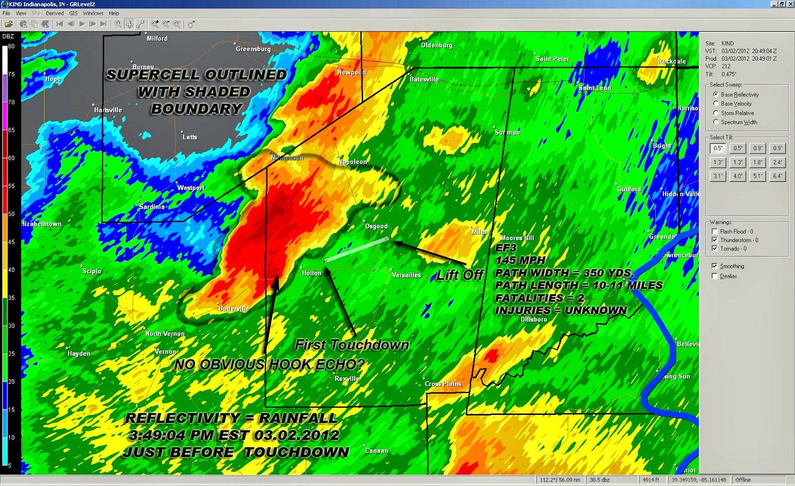
Tornado Hook Echoes
Take a look at the 4 radar images below. They are from the EF4 and EF3 tornadoes that struck the FOX19 NOW viewing area 2 March 2012. The first two images are fro just before the Crittenden-Piner-Fiskburg-Morning View tornado struck Piner, KY. The third is from the Peach Grove-Moscow-Hamersville tornado and the fourth is from the Holton, IN tornado.
 |
Here is what TCVG, the Terminal Doppler Weather Radar near CVG in Kenton County, KY at 4:21:26:57 PM EST (21:26:57 UTC) Friday 2 March 2012.The well defined hook echo, just minutes before the tornado struck Piner, KY is attenuated by heavy rain at the radar site (blank circle north of the hook). A debris ball is visible near the end of the hook. Just what is a debris ball? It is parts of houses, trees, peoples memories and prized possesions aducted and pirated away by the 160 mph winds of the EF4 Crittenden-Piner-Fiskburg-Morning View tornado.
|


No comments:
Post a Comment